24 May 2016

Geodetic Toolkit Conversion Tools

Smart web-based tools for some coordination conversion routines. The State Plane Coordinate system provides coordinates on a flat grid for easy computation while maintaining a difference between geodetic and grid distance of one part in 10,000 or better. The utilities in this package provide methods for converting between Geodetic Positions and State Plane Coordinates.

The State Plane Coordinate system divides the U.S. into a hundred or more distinct grid surfaces (Zones). Do not mix coordinates from one Zone with that in another. In you need to cross Zone boundaries, use Geodetic Positions. The utilities in this package provide methods for converting between Geodetic Positions and State Plane Coordinates or for finding an SPC Zone.
This utility uses NGS program SPCS83 or program GPPCGP to convert NAD83 or NAD27 Geodetic Positions to State Plane Coordinates (SPC)


Interactive Conversions:

  • Latitude/Longitude -> SPC
  • SPC -> Latitude/Longitude
  • Find Zone
Click here to access the tools


SPCS83 – Free PC Software Download

Converts NAD 83 state plane coordinates to NAD 83 geographic positions and conversely. Includes defining constants for NAD 83 coordinate zones. State plane coordinates are entered or computed to 1 mm accuracy, while the latitudes and longitudes entered or computed correspond to approximately 0.3 mm accuracy.

23 May 2016

Free datasets of climate change projections

NCAR's GIS Initiative Climate Change Scenarios GIS data portal. This portal is intended to serve a community of GIS users interested in climate change. The free datasets of climate change projections can be viewed on-line and/or downloaded in a common GIS (shapefile) or text file format. Many 2D variables from modelled projected climate are available for the atmosphere and land surface. These climate change projections were generated by the NCAR Community Climate System Model, or CCSM, for the 4th Assessment Report of the Intergovernmental Panel on Climate Change (IPCC).

What’s New?
·     In addition to global CCSM climate projections, downscaled projections of monthly mean temperature and total precipitation for the contiguous United States are now available. The downscaled dataset was produced using a statistical downscaling method.
·    Climate change projections from the Community Climate System Model (CCSM-3) are generated on a Gaussian grid, which is commonly used in scientific modeling. With a Gaussian grid, each grid point can be uniquely accessed by one-dimensional latitude and longitude arrays (i.e. the coordinates are orthogonal). In the CCSM model output, distributed here, the longitudes are equally spaced at 1.40625º, while the latitudes vary in spacing from 1.389º to 1.400767º. Due to irregular nature of the gridded CCSM model output this portal distributes the datasets in a point shapefile format, where each point represents a centroid of a corresponding CCSM grid cell. To more accurately represent a continuous surface of global climate, we are providing a global /polygon /dataset for use with the CCSM modeled climate projections. This polygon layer was derived using the 4 corner coordinates, based on latitude and longitude, for each grid cell of the CCSM outputs. This creates irregular, rectangular polygons, as in a Gaussian grid of the original model output. Click here for more information. 
·    A tutorial on how to analyze climate projections from the CCSM in a GIS is now available. In this demonstration, we compare model output of a present-day climate simulations with future climate projections. To download the tutorial, click here.
To access free data, you must register, login and accept data disclaimer. Please read data disclaimer carefully.

Develop Custom ArcGIS Apps for the iPad

The mobile market is made up of laptops, smartphones, and tablets. Historically dominated by the iPhone and iPad, new launches by other manufacturers have started to challenge Apple's preeminence. The most popular platforms (mobile operating systems) are Apple's iOS, Android, Symbian, Windows, and BlackBerry. Mobile device screen size is an important application development and design consideration. Screen sizes range from the 2.6-inch HP Veer through the 3.5-inch iPhone and 9.7-inch iPad 2 to the 10.1-inch Samsung Galaxy Tab. Any ArcGIS map viewer needs to be designed with the screen size in mind. Larger screen sizes lend themselves to more complex applications.

Accessing Mobile Applications
There are two ways to access applications on a mobile device. The first is to simply fire up the mobile web browser and access an existing web application. From a user's perspective, there are disadvantages to this approach. Arguably the biggest is the inability to access applications built using Adobe Flash/Flex or Microsoft Silverlight from any Apple iOS device. This relates to Apple's restrictions on installing plug-ins such as the Flash player. Thus the Esri 2.3.1 Flex viewer can be accessed from most mobile devices, but not the iPhone or the iPad 2. Apple is by no means alone in imposing these types of restrictions.
  
ArcGIS for Mobile: Development Process
The next part of the discussion focuses on the development process: from rough design to application framework to actual coding. From a programmer's perspective, this is where the fun begins. For clients and users, it is (hopefully) the evolution of a new and useful tool. This article was written in conjunction with the actual development of the application. It includes thoughts about this process as well as idle thoughts about developing mobile apps...

ASTER Global Digital Elevation Model (GDEM)

Those who are looking for higher resolution DEM, I have a very good news to convey.

All ASTER data products are now available at no charge to all users

Now, NASA/METI released the 30m global (83°N and 83°S and is composed of 22,600 1°-by-1° tiles) ASTER GDEM based on 1,264,118 single ASTER dems from 1.4 million scenes in total. 95% vertical ci: 20 meters, 95% horizontal ci: 30 meters)

ASTER GDEM is an easy-to-use, highly accurate DEM covering all the land on earth, and available to all users regardless of size or location of their target areas. Anyone can easily use the ASTER GDEM to display a bird's-eye-view map or run a flight simulation, and this should realize visually sophisticated maps. By utilizing the ASTER GDEM as a platform, institutions specialized in disaster monitoring, hydrology, energy, environmental monitoring etc. can perform more advanced analysis.


The methodology used to produce the ASTER GDEM involved automated processing of the entire 1.5-million-scene ASTER archive, including stereo-correlation to produce 1,264,118 individual scene-based ASTER DEMs, cloud masking to remove cloudy pixels, stacking all cloud-screened DEMs, removing residual bad values and outliers, averaging selected data to create final pixel values, and then correcting residual anomalies before partitioning the data into 1°-by-1° tiles. It took approximately one year to complete production of the beta version of the ASTER GDEM using a fully automated approach.

The ASTER GDEM covers land surfaces between 83°N and 83°S and is composed of 22,600 1°-by-1° tiles. Tiles that contain at least 0.01% land area are included. The ASTER GDEM is in GeoTIFF format with geographic lat/long coordinates and a 1 arc-second (30 m) grid of elevation postings. It is referenced to the WGS84/EGM96 geoid. Pre-production estimated accuracies for this global product were 20 meters at 95 % confidence for vertical data and 30 meters at 95 % confidence for horizontal data.

This was produced using ASTER data acquired from the start of observation to the end of August, 2008 in cooperation with the Japan-US ASTER Science Team. ASTER GDEM is now released and its distribution started, after the validation and the distribution site design.


ASTER GDEM tiles can be downloaded electronically from ERSDAC by visiting the link below: This web-based search system has 4 methods for tile selection. You can select tiles with one of the following methods.
  • Select tiles directly
  • Select tiles by polygon
  • Select tiles by shapefile
  • Select tiles by coordinates
OR

CSER Remote Sensing Toolkit

The aim of the toolkit is to show managers, scientists and technicians working in marine, terrestrial and atmospheric environments how images collected from satellites and aircraft (remote sensing) can be used to map and monitor environmental features or processes and their change over time.

Marine remote sensing toolkit
Marine environments encompass a broad range of environments; however, this toolkit focuses on coastal/inshore and oceanic/offshore water bodies, seagrass and coral reefs, and mangroves.
The following diagram shows the spectral signatures of benthic bottom types using different sensor types.


Terrestrial remote sensing toolkit
The “terrestrial” encompass a broad range of environments; this toolkit focuses on a range of generic land cover types, which are found across all ecosystems.


Atmospheric remote sensing toolkit
Atmospheric environments encompass the envelope of air surrounding the Earth, including its interfaces and interactions with the Earth's solid or liquid surface.
The toolkit provides a selection of worked examples and industry contacts for the procedures necessary to map Marine, terrestrial and atmospheric ecosystem properties from remote sensing. The following listing presents examples of typical users:  
  • Natural resource managers/policy makers - Can I use remotely sensed data (or a product derived from this) to map and monitor a terrestrial ecosystem health indicator in the range of environmental conditions experienced in the terrestrial environment I am responsible for?  
  • Natural resource scientists/technicians - Which indicators of terrestrial ecosystem health can I accurately map and monitor in my terrestrial environment using commercially available remote sensing data and what are the basic resources, personnel and time required to do this?  
  • Spatial information professionals - How can I use remote sensing to accurately map and monitor in my terrestrial environment using commercially available remote sensing data and what are the basic resources, personnel and time required to do this? 
  • Students - How can remotely sensed data be used to map and monitor terrestrial ecosystem health indicator(s) in the range of environmental conditions typically experienced in the terrestrial environment? 
  • General public - What type of information can be accurately mapped and monitored from remotely sensed data of terrestrial environments?

Seamless Data Warehouse

The Seamless Data Warehouse is the ideal location to explore and retrieve data. U.S. Geological Survey (USGS) and the Earth Resources Observation and Science (EROS) are committed to providing access to geospatial data through The National Map. An approach is to provide free downloads of national base layers, as well as other geospatial data layers. These layers are divided into framework categories.
  • Places
  • Structures
  • Transportation
  • Boundaries
  • Hydrography
  • Orthoimagery
  • Land Cover
  • Elevation
The Seamless Data Warehouse capabilities include:

  • Free downloads up to 3 Gigabytes of data in 250 Megabyte files per request: Users have unlimited access to the interactive map and can make unlimited requests. The amount of coverage area depends on the number of products selected for download. For example, if NED 1 Arc Second is selected as the only product a user can download up to a 30 square degree area. But, if NED 1 arc second and NED 1/3 arc second are selected, then the area available for download will be considerably smaller. To see the various sizes of coverage area for each product, click on the List of Products drop down on the right side of the viewing area and select the desired product.
  • User can define an area of interest by drawing a box, defining coordinates, or use available templates to cut out the area: The first method of drawing a box (square or rectangle) is best for defining a general area. The coordinates are displayed, in decimal degrees, in the bottom left corner of the window as the mouse is moved over the map. The second method of defining coordinates can be used when the user wants a precise area and knows the corner coordinates. The third method is the use of provided templates, such as 7.5 minute quadrangles.
  • Tiled Data Distribution System (TDDS) : allows a user to access historical data from the EROS storage system. The concept of The National Map Seamless Server is to provide the best available data. High resolution orthoimagery, the best available will change approximately every couple of years as new imagery becomes available. The older imagery will be removed from The National Map Seamless Server and map services and made available using TDDS.
  • Query tools are provided to acquire more information about the an area of interest: An example of the two query tools are Elevation Point and Elevation Profile. The elevation point tool allows a user to click anywhere on the map interface and an elevation will be returned, in feet, as well as the coordinates. The elevation profile tool will provide a cross section graph between two points, in any direction.
Sample data map:

Tools to Access Data:
  • ArcGIS Toolbar
  • Mapping Services
  • Application Services
  • Tiled NED Tool
  • Inventory Search
  • Seamless Viewer
  • TNM Viewer
The Seamless Data Warehouse is always growing with new data, tools, features, and much more.


National Geophysical Data Center (NGDC)

NGDC provides stewardship, data, products and services for geophysical data describing the solid earth, marine, and solar-terrestrial environment, as well as earth observations from space. 

Key Features and Services:
  • Free Downloadable Data
  • Interactive Map Services
  • Metadata Catalog
  • Online Data Access Systems
  • Products by Media Types
Data categories:
  • Hazards
  • Marine
  • Satellite
  • Snow & Ice
  • Solar-Terrestrial
Available Data Types:
Aeromagnetic Data, Aurora, Bathymetry/Topography, Climatology, Coastlines, Computer Imagery, Cosmic Rays, Defence Meteorological (DMSP), Earthquake, Environmental Data, GIS Data, GPS (CORS), Geochemistry, Geodetic (GEOSAT), Geographic Boundaries, Geology, Geomagnetism, Geostationary (GOES), Gravity Data, Great Lakes, Habitat Characterization, Ionosphere, Magnetic Data, Marine Geology, Marine Geophysics, Marine Minerals, Marine Sediment and Rock, Marine Seismic Reflection Data, Marine Well Logs, Multi-beam Bathymetry, Natural Hazards, Ocean Drilling, Pale-oceanography, Satellite Data, Snow and Ice, Solar Data, Tsunamis and Volcanology.
Sample Map 1:

Sample Map 2:

NGDC's data holdings currently contain more than 400 digital and analog databases, some of which are very large. As technology advances, so does the search for more efficient ways of preserving these data.

NGDC works closely with contributors of scientific data to prepare documented, reliable data sets and welcoming cooperative projects with other government agencies, nonprofit organizations, and universities, and encourage data exchange.
The Data Centre continually develops data management programs that reflect the changing world of geophysics and welcoming your input to their programs and look forward to supplying your data needs.

Global Map of Irrigation Areas (Latest ver 5.0)

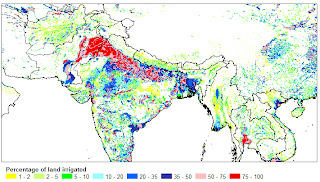
Now, the Latest Global Map of Irrigation Areas (Latest version 5.0) is available as a FREE download. The map shows the amount of area equipped for irrigation around the turn of the 20th century in percentage of the total area on a raster with a resolution of 5 minutes. The area actually irrigated was smaller, but is unknown for most countries. A special note has to be made for Australia and India where the map shows the total area actually irrigated. This is due to the fact that statistics collected in Australia and India refer to actually irrigated area as opposed to statistics with area equipped for irrigation which are collected in most other countries. An explanation of the different terminology to indicate areas under irrigation is given in the glossary.

For the GIS-users the map is distributed in two different formats:
  • as zipped ASCII-grid that can be easily imported in most GIS-software that support rasters or grids;  

  • and, to accommodate people who use GIS-software that doesn't support rasters or grids, as a zipped ESRI shape file.

The documentation of the map includes an explanation of the methodology, information per country, an assessment of the map quality, and references to the background and history of the irrigation mapping project. Users of Google Earth can see the Global Map of Irrigation Areas as an overlay by opening this file in Google Earth.
Sample Map 1
Sample Map 2

The map is generated as a grid and distributed with the following characteristics:


Projection Geographic
Number of columns 4320
Number of rows 2160
North Bounding Coordinate 90 degrees
East Bounding Coordinate 180 degrees
South Bounding Coordinate -90 degrees
West Bounding Coordinate -180 degrees
Cell size 5 minutes,  0.083333 decimal degrees
NODATA values Cells without irrigation are characterised by NODATA (-9), it does not mean that there was no data for these cells


Map versions
arrowVersion 5 - Global update to map version 5.0
arrowVersion 4.0.1 - Irrigation in Africa, Europe and Latin America
arrowVersion 4.0 - Pre-release of map version 4.0
arrowVersion 3.0  - An update for North America
arrowVersion 2.2 - An update for Asia
arrowVersion 2.1 - Updates for Africa and Oceania
arrowVersion 2.0 - An update for Latin America and Europe
arrowVersion 1.0 - A Digital Global Map of Irrigated Areas

FREE ArcGIS Explorer Desktop with ArcGIS Online

Easier Sharing, Attribute Table Display, and New Presentation Tools Are Among Improvements

The most recent ArcGIS Explorer Desktop release includes new features and enhancements to make it a more powerful tool in an enterprise GIS, including content sharing via ArcGIS Online, tabular information display, and new presentation tools. ArcGIS Explorer Desktop is a free GIS viewer that enables the exploration and visualization of GIS information.
The new version of ArcGIS Explorer Desktop allows users to upload GIS content directly to ArcGIS Online accounts, where anyone with Internet access can see it. Integrating ArcGIS Explorer with ArcGIS Online and Portal for ArcGIS, Esri's on-premises cloud expands its support for role assignment, creation of custom basemap galleries, and organization-specific searches. Users can search shared content on ArcGIS Online or private content hosted using Portal for ArcGIS.
New ArcGIS Explorer Desktop 2500 includes the following enhancements:
  • Ability to easily upload GIS content directly to your ArcGIS Online account
  • Added support for ArcGIS Online and Portal for ArcGIS sharing, roles, custom basemap galleries, and organization-specific search
  • Capability to display attribute tables for feature layers
  • Presentation tools such as slide animations, timed transitions, audio synchronization, and presentation mark up
  • ArcGIS Explorer Desktop can be run off of an external USB connected drive on any computer that meets the ArcGIS Explorer Desktop.
  • Size and position of popup windows can be controlled
  • Support for KML tours
  • Ability to use custom locators


The free download of ArcGIS Explorer Desktop is available from : http://www.esri.com/software/arcgis/explorer

Free SRTM 90m Data for the entire world !

Download SRTM 250m or 90m Digital Elevation Data (Version 4.1) The SRTM Data now available from CSI-CGIAR SRTM Data portal. This is Free, and all the data has been upgraded to version 4.1. This latest version represents a significant improvement from previous versions, using new interpolation algorithms and better auxiliary DEMs.

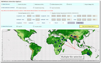
For quick and easy data downloads, this portal has a nice user-friendly web interface which provides users three flexible options to choose, in order to selecting multiple tiles for downloading.


1. Multiple tile selection by clicking on tiles
2. Drag the mouse-point on top of the world map and mark & select the tiles
3. or, enter lat-long input coordinates.
In addition, you can switch between their different hosting servers, to select either HTTP or FTP downloads.

Just open the below image and see how easy it is !
The CGIAR-CSI GeoPortal is able to provide SRTM 90m and 250m Digital Elevation Data for the entire world. The SRTM digital elevation data, produced by NASA originally, is a major breakthrough in digital mapping of the world, and provides a major advance in the accessibility of high quality elevation data for large portions of the tropics and other areas of the developing world. The SRTM digital elevation data provided on this site has been processed to fill data voids, and to facilitate it's ease of use by a wide group of potential users. This data is provided in an effort to promote the use of geospatial science and applications for sustainable development and resource conservation in the developing world. Digital elevation models (DEM) for the entire globe, covering all of the countries of the world, are available for download on this site.


The SRTM 90m DEM's have a resolution of 90m and 250m at the equator, and are provided in mosaiced 5 deg x 5 deg tiles for easy download and use. All are produced from a seamless dataset to allow easy mosaicing. These are available in both ArcInfo ASCII and GeoTiff format to facilitate their ease of use in a variety of image processing and GIS applications. Data can be downloaded using a browser or accessed directly from the ftp site

For more information and direct FREE data downloads, visit:http://srtm.csi.cgiar.org/
OR If you want to go DIRECTLY to Data Download page: CLICK HERE !

UNEDP Environmental Data Explorer

UNEDP's Environmental Data Explorer is the authoritative source for data sets used by UNEP and its partners in the Global Environment Outlook (GEO) report and other integrated environment assessments. Its online database holds more than 500 different variables, as national, subregional, regional and global statistics or as geospatial data sets (maps), covering themes like Freshwater, Population, Forests, Emissions, Climate, Disasters, Health and GDP. Display them on-the-fly as maps, graphs, data tables or download the data in different formats.


The navigation within the Environmental Data Explorer is fairly easy and straightforward. In most cases you will have to select something (eg. a dataset, years, a module etc.), before being able to continue in the process. After having done your selection, you just have to click on the button to proceed in the process. If you like to return to revisit or change the options you use the button.
If your selected values are what you need, but you want to treat the data further on your computer, then download the data in different version, ranging from simple text to Excel and GIS formats.
Also, by clicking on the map image, you will enter onto an Internet Map Server (IMS), which produces on-the-fly a map covering your selected attributes (variable, region, time). You can zoom into the map to get more details, identify a countries name and value, produce a graph etc.
Sample Map
to visit UNEDP Environmental Data Explorer!


You may also like:

FAIR USE NOTICE: This site contains copyrighted material the use of which has not always been specifically authorized by the copyright owner. We are making such material available in our efforts to advance understanding of environmental, political, human rights, economic, democracy, scientific, and social justice issues, sustainable development, environmental, community and worker health, democracy, public disclosure, corporate accountability, and social justice issues, etc. We have included the full text of the article rather than a simple link because we have found that links frequently go "bad" or change over time. We believe this constitutes a "fair use" of any such copyrighted material as provided for in section 107 of the US Copyright Law. In accordance with Title 17 U.S.C. Section 107, the material on this site is distributed without fee or payment of any kind to those who have expressed a prior interest in receiving the included information for research and educational purposes. If you wish to use copyrighted material from this site for purposes of your own that go beyond 'fair use', you must obtain permission from the copyright owner.